


Visualizing Planned Construction For Site Selection
When it comes to selecting the right site for a construction project, making informed decisions is crucial. The location of a project can significantly impact its success, profitability and overall efficiency. Traditional site selection methods often rely on static data and limited information, leading to potential risks and missed opportunities. However, with the advancement of technology, planned construction visualization has emerged as a powerful tool that revolutionizes the site selection process.
At BuildCentral, we understand the challenges faced by site selectors in identifying the best sites for construction projects. As a leading provider of construction industry data and solutions, we’ve developed state-of-the-art tools that harness the power of planned construction visualization. By leveraging our tools, site selectors can gain a competitive edge and make well-informed decisions that drive successful outcomes. Read our post on How to Get Construction Leads.
In this blog post, we’ll explore the significance of planned construction visualization in site selection and dive into how BuildCentral’s tools can assist site selectors in choosing the best sites. From our Geospex project map to location analytics, our tools empower you to visualize planned construction projects and unlock a wealth of insights that traditional methods can’t provide. Let’s dive into the transformative potential of planned construction visualization.

Why site selection experts rely on planned construction visualization
In the world of site selection, relying solely on static data and traditional methods can be limiting. However, the advent of planned construction visualization has opened up new possibilities and enhanced the decision-making process. By visualizing planned construction projects, site selectors can gain valuable insights and make informed choices that align with their project goals. Here’s why planned construction visualization is a game changer:
1. Overcoming Challenges of Traditional Site Selection Methods:
Traditional site selection methods often rely on paper-based documents, maps and spreadsheets. While these sources provide valuable information, they lack the visual context necessary to fully understand the impact of a planned construction project on its surroundings. Planned construction visualization addresses this limitation by presenting the project in a visual format, allowing site selectors to evaluate its potential effects on the site, nearby infrastructure and the community.
2. Unveiling Crucial Insights:
Visualizing planned construction projects provides site selectors with a comprehensive understanding of the project’s scale, design and potential implications. By virtually exploring the project site and its surroundings, you can assess factors such as accessibility, zoning regulations, proximity to amenities and potential challenges. See how you can Find Grocery Backfill Project with Location Analytics.
3. Virtual Site Visits and 3D Modeling:
Planned construction visualization tools offer the ability to conduct virtual site visits, eliminating the need for physical travel and saving both time and resources. Site selectors can explore the project site from different perspectives, view proposed building designs and assess the site’s suitability without leaving their offices. Furthermore, 3D modeling capabilities provide a realistic representation of the future construction, allowing you to visualize the project’s impact on the surrounding area and make accurate assessments.
4. Enhanced Decision Making and Risk Mitigation:
The ability to visualize planned construction projects empowers site selectors to evaluate various scenarios and anticipate potential risks and challenges. By assessing the visual impact of a project on neighboring properties, traffic pattern, and environmental factors, you can proactively address any issues and mitigate risks before they become costly problems.
Planned construction visualization is a powerful tool that transforms site selection by providing a visual context that goes beyond traditional data points. By harnessing this technology, site selectors can make informed decisions, mitigate risks and choose sites that maximize the potential for project success. In the next section, we’ll introduce BuildCentral’s planned construction visualization tools, which are specifically designed to assist site selectors in their quest to find the best sites.
How Planned Construction Visualization Helps Site Selectors Choose the Right Construction Sites

When it comes to choosing the right construction site, leveraging planned construction visualization is key for site selectors like you. By utilizing these visualization tools, you can make well-informed decisions and select sites that align with your project goals. Here’s how planned construction visualization can help you choose the right construction sites:
1. Enhanced Understanding of Project Impact:
By visualizing planned construction projects in their intended locations, you can gain a comprehensive understanding of their potential impact. This visualization allows you to assess factors such as the project’s scale, design and how it fits into the surrounding environment. By visualizing the project’s impact on neighboring properties, transportation infrastructure and the community, you can evaluate whether the site is suitable for your specific project requirements.
2. Evaluation of Site Accessibility:
Planned construction visualization enables you to assess the accessibility of potential construction sites. By virtually exploring the site and its surroundings, you can evaluate factors such as proximity to transportation networks, road connectivity, and ease of access for suppliers, employees, and customers. This evaluation ensures that the selected site is conveniently located and easily accessible for all stakeholders involved in the project.
3. Identification of Potential Challenges and Risks:
Visualizing planned construction projects allows you to identify potential challenges and risks associated with a particular site. By assessing the visual impact of the project on the surrounding area, you can anticipate any obstacles that might arise during the construction process or after completion. This proactive approach helps you mitigate risks, address potential issues upfront and ensure a smoother project execution.
4. Evaluation of Compatibility with Project Requirements:
By visualizing planned construction projects, you can assess whether a site aligns with your project’s specific requirements. This includes considerations such as the size of the site, zoning regulations and any limitations or restrictions that might impact your project’s feasibility. By evaluating these factors through planned construction visualization, you can ensure that the selected site meets all the necessary criteria for a successful project.
5. Comparison of Multiple Site Options:
Planned construction visualization tools allow you to compare multiple site options simultaneously. By visualizing various sites and their respective planned construction projects, you can make direct comparisons based on factors such as location, scale, design and potential impact. Read our post on How to Find Residential Rezoning Construction Leads.
BuildCentral’s Planned Construction Visualization Tools
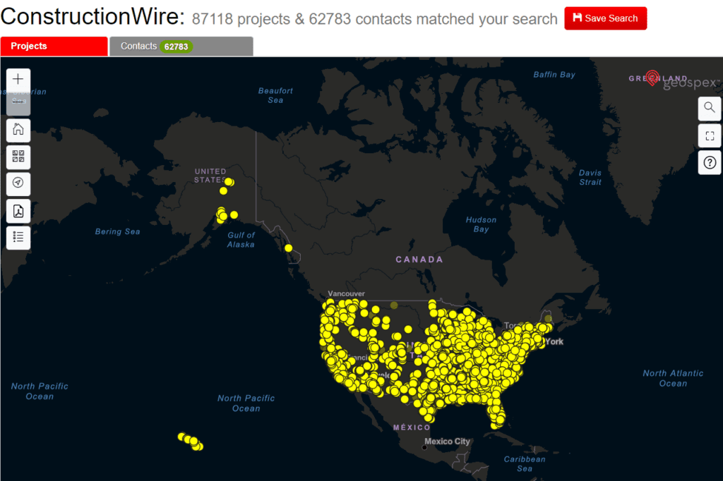
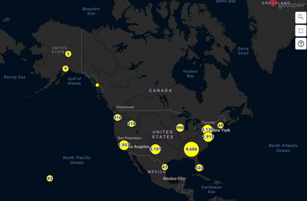
There are over 80,000 planned projects on our analytics map, Geospex. At BuildCentral, we recognize the transformative potential of planned construction visualization in site selection. With our expertise in construction industry data and cutting-edge technology, we’ve developed a suite of tools that revolutionize the way site selectors choose the best sites. Let’s explore the features and capabilities of our planned construction visualization tools:
1. Comprehensive Construction Data:
BuildCentral aggregates a vast amount of construction industry data from various sources, ensuring that site selectors have access to the most up-to-date and accurate information. Our database covers a wide range of construction projects, including commercial, multifamily, hotel, medical and more. This data serves as the foundation for our planned construction visualization tools, enabling site selectors to explore projects with a high level of detail and accuracy.
2. Interactive Mapping and Visualization:
Our Geospex map provides intuitive and interactive mapping capabilities that allow you to visualize construction projects in their geographical context. By seamlessly navigating through different layers of data, you can gain a comprehensive understanding of the project’s location, surroundings and potential impact.
3. Real-Time Updates and Notifications:
Keeping pace with construction industry developments is crucial for effective site selection. BuildCentral’s tools offer real-time updates and notifications, ensuring that you have access to the latest information on planned construction projects.
4. Integration with Site Selection Factors:
Our planned construction visualization tools seamlessly integrate with other critical site selection factors, such as demographics, market trends, transportation infrastructure and more. Check out our article on How to find Backfill Leads for Big-Box Retailers.
BuildCentral’s planned construction visualization tools empower site selectors with the insights and info necessary to choose the best sites for their construction projects. Take advantage of our Gesospex map to easily visualize planned construction projects across the US.
Visualize Planned Construction Sites Now
Planned construction visualization has emerged as a powerful tool in the site selection process, revolutionizing how site selectors choose the best construction sites. By leveraging visual representations of planned construction projects, you can make informed decisions, mitigate risks and ensure the success of your projects.
With BuildCentral’s tools, site selectors can gain a competitive edge, evaluate projects with detailed analysis and explore different scenarios to identify the most suitable sites. By visualizing the impact of construction projects, assessing site accessibility, anticipating challenges and aligning with project requirements, site selectors can make confident decisions that set their projects up for success.
Incorporating planned construction visualization into your site selection process unlocks a world of possibilities, enabling you to choose the right construction sites that align with your project goals and objectives. By harnessing the power of visualization, you can mitigate risks, optimize decision-making and maximize the potential for project success.
We encourage you to explore the capabilities of planned construction visualization we have on BuildCentral and experience the transformative impact we can have on your site selection process. Whether you’re involved in commercial, multi/single family, hotel, medical or other construction projects, incorporating visualizations will undoubtedly enhance your decision-making process and increase the likelihood of achieving desired outcomes.
Choose the power of planned construction visualization and elevate your site selection process to new heights. Embrace the future of site selection and unlock the full potential of your construction projects.
If you’re interested in posting or bidding on constructions projects, RFPs and/or RFQs, check out QuestCDN. QuestCDN, a subsidiary of BuildCentral, is the premier project posting and digital bidding platform. You can easily post or find projects, download all docs and seamlessly submit or receive proposals.
Start a free demo to see the power of our platform.
Read all of our blog posts here: BuildCentral Blog.