


Announcing the Release of Geospex™, a Planned Construction Visualization Tool from ConstructionWire
June 22, 2021 By David Z Beitz
It has been a busy few months since the Planned Grocery team was acquired by Hubexo, the parent company to Chicago-based ConstructionWire.
If you are not familiar with Planned Grocery, the Planned Grocery platform was created by retail real estate professionals George Daigh, Todd Atkins, and myself (David Beitz) for organizations to have a better understanding of where new grocery stores are planned and when they will open.
Launched in early 2016, the subscription platform quickly gained a following from companies in the commercial real estate space including Whole Foods, Philips Edison and Company, Fresh Direct, and ShopCore.
Today the platform is primarily used by organizations seeking to track grocery competition as well as for site selection for new grocery store locations.
After the Planned Grocery acquisition earlier this year, our first priority was to make the BuildCentral residential data available inside the Planned Grocery platform.
This addition gives Planned Grocery customers the ability to see where new residential developments (multi-family and single-family) are planned and under construction. Those focused on market planning and site selection now have a new way to see where new residential growth is happening.
You can get the full details here: https://www.buildcentral.com/upcoming-grocery-construction/
Now I am excited to report on our next project!
Starting today, ConstructionWire is offering a new location analytics product. Built on the core technology that fuels Planned Grocery insights, this new product is called Geospex™.
Geospex™, using ESRI technology, gives users the ability to better understand and analyze planned construction projects in the United States across all building categories.
ConstructionWire customers using Geospex™ will be able to activate new location-based layers to help with market analysis, site selection, due diligence, and business development.
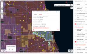
Screengrab of Geospex™ Planned Construction Visualization Tool
Geospex™ gives users the ability to better visualize data on upcoming construction projects and offers many more data layers and functionality than its basic mapping functionality.
For example, general contractors will be better equipped to bid on projects by knowing location attributes such as the crime index, bedrock depth, and proximity to environmental hazards, all data layers featured in Geospex.
Those in real estate, finance and site selection will be able to narrow down sites based on data layers such as planned construction projects, flood zones, opportunity zones, geology, and property lines.
Lastly, those selling materials into new buildings will have a way in Geospex™ to upload custom data with our new custom data program and assess development trends by region.
And this all just scratches the surface.
Existing ConstructionWire customers have already received new standard mapping functionality at no additional cost which gives the user the ability to map many more projects than the current technology allows as well as the ability to overlay new spatial layers.
These new layers for the standard mapping include CBSA’s (Core Based Statistical Areas), Counties, and Zip Codes.
If your company has anything to do with real estate, construction or finance, I suggest you check out Geospex™ and Planned Grocery™ available from ConstructionWire. Knowing what is planned helps our customers to identify opportunities and risks, as well as visualize where the competition is headed in the future.
Learn more about how to discover more opportunities and mitigate risk with dynamic construction data and leading-edge location analytics all in one platform.
Any thoughts on this blog? Feel free to contact me at David@PlannedGrocery.com
If you would like more info on Geospex™ please contact Alex DeLoach at Alex@PlannedGrocery.com or give us a call at 888.511.5866.
Request a free trial today to learn more about ConstructionWire’s products, and to start tracking everything from warehouse and industrial projects to retail, hotel, medical, CRE, multifamily, and mixed-use developments.